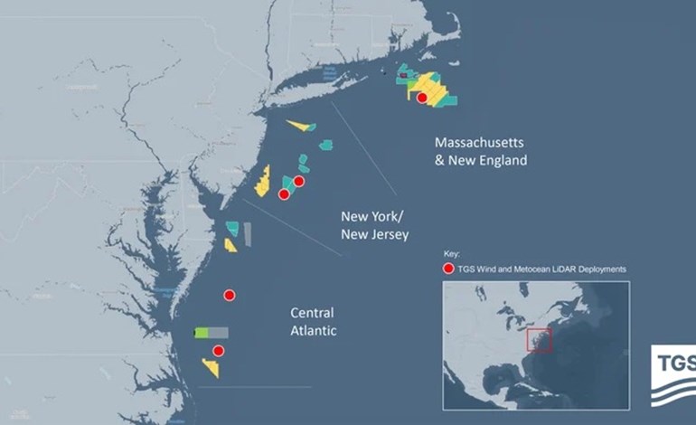
TGS has concluded a comprehensive regional wind and metocean data collection campaign along the US East Coast, in preparation for the Central Atlantic Offshore Wind auction. This campaign, which spanned nearly 600 kilometers from Massachusetts to the Virginia/North Carolina border, involved the deployment and operation of five offshore LiDAR buoys.
The data collection, conducted from July 2022 through July 2024, was carried out under TGS’s multi-client approach. This model allows multiple customers to subscribe to the same floating LiDAR data, which helps offshore wind stakeholders reduce costs and timescales associated with acquiring bankable wind and metocean data while minimizing energy uncertainty, the company stated.
TGS used the collected data to bias-correct its high-resolution Numerical Weather Prediction (NWP) model simulations. Both the quality-controlled measurement data and the bias-corrected NWP model data are being used by developers to refine their bidding strategies for the Bureau of Ocean Energy Management’s (BOEM) upcoming Central Atlantic offshore wind lease auction. TGS noted that the measured LiDAR data revealed significantly different wind speeds compared to prior wind modeling studies, demonstrating the value of direct measurements and the risks of relying on uncorrected model results for decision-making.
The company highlighted that providing relevant data to the industry ahead of the Central Atlantic offshore wind auction would enable bidding developers to understand energy potential accurately and make informed decisions. A comprehensive range of wind and metocean data was collected at each site, including wind speed and direction across various turbine hub heights, wave heights, and ocean current data across the full water column.
Additionally, four of the five buoys were equipped with in-air acoustic recording devices to monitor bird and bat activity, seabed-mounted sensors to measure additional metocean parameters, and whale and porpoise acoustic monitors to identify marine mammal vocalizations. These measurements provide a unique dataset recorded across a vast stretch of the US coast, offering exclusive insights for mega modeling, extreme weather event studies, and wide-scale calibration of numerical models.
Carel Hooijkaas, executive vice president of New Energy Solutions at TGS, commented, “These unique measurements empower developers to accurately assess the true wind resource variability across most of the US East Coast offshore wind lease areas.”
Data was continuously acquired and quality-controlled throughout the deployment, with customers receiving daily access via the Wind AXIOM platform, TGS’s site evaluation and wind data analytics tool. TGS noted that the combined measurement campaign and its baseline model derivatives are designed with longevity in mind, providing a premier baseline dataset for wind resource analysis for future lease sales and project construction over the next 15 years.

